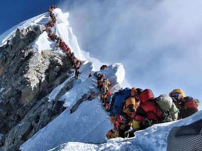
Mount Everest is the highest mountain on planet Earth, with an altitude of 8848 meters (29 029 feet). It is located in the Asian continent, in the Himalayas, specifically in the sub-mountain range of Mahalangur Himal; marks the border between the People’s Republic of China and Nepal. The massif includes the neighboring peaks Lhotse, 8516 m (27 940 ft); Nuptse, 7855 m (25 771 ft) and Changtse, 7580 m (24 870 ft).
Mount Everest has two main routes of ascent: the route on the southwest side or via the South pass, from Nepal, and the northeast route or North Col. route, from Tibet, as well as other 13 less, frequented routes. Of the two main routes, the most technically easy and most used is the southwest. It was the route used by Hillary and Tenzing in 1953 and the first of the 15 routes described in 1996.
During this season, two climbers, Cory Richards, and Estaban “Topo” Mena set out to open a new route along the highest peak in the world. It had been 10 years since a new Everest line was established, and the route that Richards and Mena had had in their eyes had been tried unsuccessfully four years before.
Climbers united for a purpose
Now, after a ‘crowded’ Everest season, two climbers are trying to forge a new route.
Both climbers were intimately familiar with the dangerous Everest raffle. Together, they have walked 29,029 feet to the top six times.
It should be noted that there are approximately 20 named routes established on Everest, the most recent in 2009 by a Korean team. But only three percent of the approximately 7,000 registered summits have occurred on one of these other routes, according to the Himalayan Database. Most climbers adhere to the two main routes because they are the most established, have fewer unknowns and are chartered by expeditions, according to climbing experts.
Thus, the couloir, a steep and narrow ravine, which caught the interest of Richards and Mena, runs down the northeast face and then intersects with the northeast ridge. When entering the end of the route at approximately 21,325 feet, the first section will consist of moderate snow. The hardest section would start around 25,574 feet, where the air is dangerously thin, consisting of difficult terrain, ice stairs and snow ramps. After this, they would begin to cross towards the north face of the mountain, and eventually, they would cross the normal route. Here they would have the option to continue along the established ascent or complete the complete and independent line.
Source: Liz Weber, The Washington Post | National Post

No comments:
Post a Comment